NIT Rourkela, TIH IIT Patna get patent for India’s 1st real-time land mapping drone system
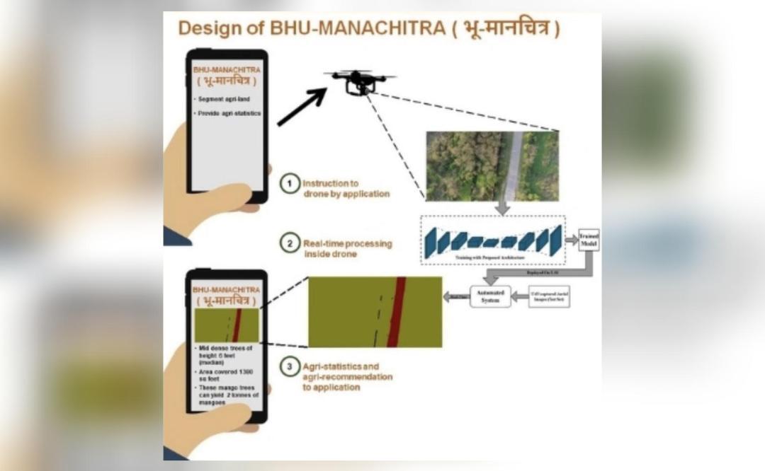
In a groundbreaking achievement, the National Institute of Technology (NIT) Rourkela and the Vishlesan I-Hub Foundation (TIH) at the Indian Institute of Technology (IIT) Patna have jointly received a patent for India’s first autonomous real-time land mapping drone system. This innovative system, dubbed ‘BHU-MANACHITRA’, has the capability to generate maps without the need for internet or manual intervention, making it a self-sufficient and valuable tool, particularly in remote locations.
The ‘BHU-MANACHITRA’ system utilizes a lightweight artificial intelligence (AI) model and unmanned aerial vehicle (UAV) technology to create detailed maps of the terrain in real-time. This technology has far-reaching implications for various fields, including urban planning, disaster management, and environmental monitoring. The fact that it can operate without internet connectivity or human intervention makes it an ideal solution for areas where access to these resources is limited.
According to the researchers involved in the project, the ‘BHU-MANACHITRA’ system is a significant breakthrough in the field of land mapping. “The system is self-sufficient and especially valuable in remote locations,” they said. This is because traditional land mapping methods often require extensive human resources, time, and equipment, making them impractical for areas that are difficult to access. In contrast, the ‘BHU-MANACHITRA’ system can quickly and efficiently generate detailed maps, even in areas with limited infrastructure.
The potential applications of this technology are vast. For instance, in urban planning, the ‘BHU-MANACHITRA’ system can be used to create detailed maps of cities, helping planners to identify areas that require development or infrastructure upgrades. In disaster management, the system can quickly generate maps of affected areas, allowing emergency responders to respond more effectively. Additionally, the system can be used to monitor environmental changes, such as deforestation or soil erosion, enabling policymakers to take proactive measures to mitigate these issues.
The development of the ‘BHU-MANACHITRA’ system is a testament to the innovative spirit of Indian researchers and institutions. The collaboration between NIT Rourkela and TIH IIT Patna demonstrates the power of interdisciplinary research and the potential for Indian institutions to make significant contributions to the global scientific community.
The patent received by NIT Rourkela and TIH IIT Patna is a recognition of the novelty and innovation of the ‘BHU-MANACHITRA’ system. The patent will enable the institutions to commercialize the technology, making it available to a wider range of users and applications. This, in turn, is expected to have a positive impact on various sectors, from urban planning to environmental monitoring.
In conclusion, the development of the ‘BHU-MANACHITRA’ system is a significant achievement for Indian research institutions. The system’s ability to generate maps in real-time, without internet or manual intervention, makes it a valuable tool for a range of applications. The patent received by NIT Rourkela and TIH IIT Patna is a recognition of the innovation and novelty of the system, and it is expected to have a positive impact on various sectors.
As India continues to invest in research and development, it is likely that we will see more innovative technologies like the ‘BHU-MANACHITRA’ system emerge. The collaboration between NIT Rourkela and TIH IIT Patna is a model for future research collaborations, demonstrating the potential for Indian institutions to make significant contributions to the global scientific community.
The ‘BHU-MANACHITRA’ system is an example of how technology can be used to address real-world problems, and its development is a testament to the ingenuity and creativity of Indian researchers. As the system is commercialized and made available to a wider range of users, it is likely to have a significant impact on various sectors, from urban planning to environmental monitoring.
In the coming years, it will be exciting to see how the ‘BHU-MANACHITRA’ system is used in various applications, and how it contributes to the development of India’s infrastructure and economy. The patent received by NIT Rourkela and TIH IIT Patna is a significant milestone in the development of this technology, and it is a recognition of the innovative spirit of Indian researchers and institutions.