How does Sentinel-2 protect India’s biodiversity?
India is home to a vast and diverse range of ecosystems, from the majestic Himalayas to the lush Western Ghats, and from the arid Thar Desert to the mangrove forests of the Sundarbans. The country’s rich biodiversity is not only a source of national pride but also provides essential ecosystem services, including air and water purification, soil conservation, and climate regulation. However, India’s biodiversity is facing unprecedented threats, including habitat destruction, pollution, climate change, and invasive species. To combat these threats, scientists at the Indian Space Research Organisation (ISRO), Indian Institute of Space Technology (IIST), and Gujarat University have developed a new satellite mapping system, Sentinel-2, which can identify submerged plants with 94% accuracy.
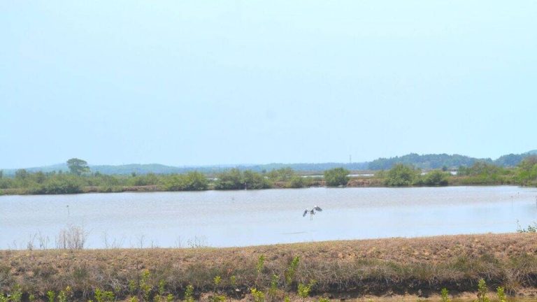
The Sentinel-2 satellite mapping system is a revolutionary technology that uses advanced remote sensing techniques to monitor the health of India’s wetlands. Wetlands are crucial ecosystems that provide habitat for a wide range of plant and animal species, and play a vital role in maintaining water quality, preventing floods, and supporting fisheries. However, India’s wetlands are facing numerous threats, including encroachment, pollution, and climate change, which can lead to the decline of vital plant life. The Sentinel-2 system has been used to monitor 500 of India’s largest wetlands, and the results are alarming.
The study, which used Sentinel-2 data, found that nearly 100 lakes, mostly in central and southern India, are experiencing a major decline in vital plant life. This decline is not only a threat to the biodiversity of these ecosystems but also has significant implications for the livelihoods of people who depend on these wetlands for fishing, agriculture, and other economic activities. The study’s findings call for urgent climate actions to protect India’s wetlands and the plant life that they support.
The Sentinel-2 system is a powerful tool for monitoring the health of India’s wetlands. The system uses a combination of satellite imagery and machine learning algorithms to identify submerged plants and monitor changes in their distribution and abundance over time. The system’s high accuracy rate of 94% makes it an essential tool for conservation efforts, allowing scientists and policymakers to identify areas that require urgent attention and develop effective strategies for protecting India’s wetlands.
The development of the Sentinel-2 system is a significant achievement for Indian scientists, who have been working tirelessly to develop new technologies for monitoring and protecting the country’s biodiversity. The system’s potential applications are vast, and it could be used to monitor a wide range of ecosystems, including forests, grasslands, and marine ecosystems. The system could also be used to track the spread of invasive species, monitor the impact of climate change on ecosystems, and identify areas that require conservation efforts.
The decline of plant life in India’s wetlands is a complex issue that requires a multifaceted approach. Climate change, pollution, and encroachment are all major contributors to the decline of plant life in these ecosystems. To address these issues, the Indian government has launched several initiatives, including the National Wetland Conservation Programme, which aims to conserve and manage India’s wetlands in a sustainable manner. The programme includes measures such as habitat restoration, species conservation, and community engagement, and has the potential to make a significant impact on the health of India’s wetlands.
In addition to government initiatives, there are several steps that individuals can take to protect India’s wetlands and the plant life that they support. These include reducing our carbon footprint, using public transport, carpooling, or driving electric or hybrid vehicles, reducing water pollution by using eco-friendly cleaning products and disposing of waste properly, and supporting organizations that work to conserve and protect India’s wetlands.
In conclusion, the Sentinel-2 satellite mapping system is a powerful tool for protecting India’s biodiversity. The system’s ability to identify submerged plants with 94% accuracy makes it an essential tool for conservation efforts, and its potential applications are vast. The decline of plant life in India’s wetlands is a complex issue that requires a multifaceted approach, and it is essential that we take urgent climate actions to protect these ecosystems. By working together, we can ensure the long-term health and sustainability of India’s wetlands and the plant life that they support.
The development of the Sentinel-2 system is a significant achievement for Indian scientists, and it highlights the importance of continued investment in scientific research and development. The system’s potential to monitor and protect India’s biodiversity is vast, and it has the potential to make a significant impact on the health of the country’s ecosystems.
As we move forward, it is essential that we continue to develop and implement new technologies for monitoring and protecting India’s biodiversity. The Sentinel-2 system is just one example of the innovative solutions that are being developed to address the complex environmental challenges that India faces. By working together and using these technologies, we can ensure the long-term health and sustainability of India’s ecosystems and the plant life that they support.
News Source: https://researchmatters.in/news/satellite-monitoring-reveals-declining-plant-life-hundreds-indian-wetlands