Pic shows volcano’s eruption in Ethiopia from space
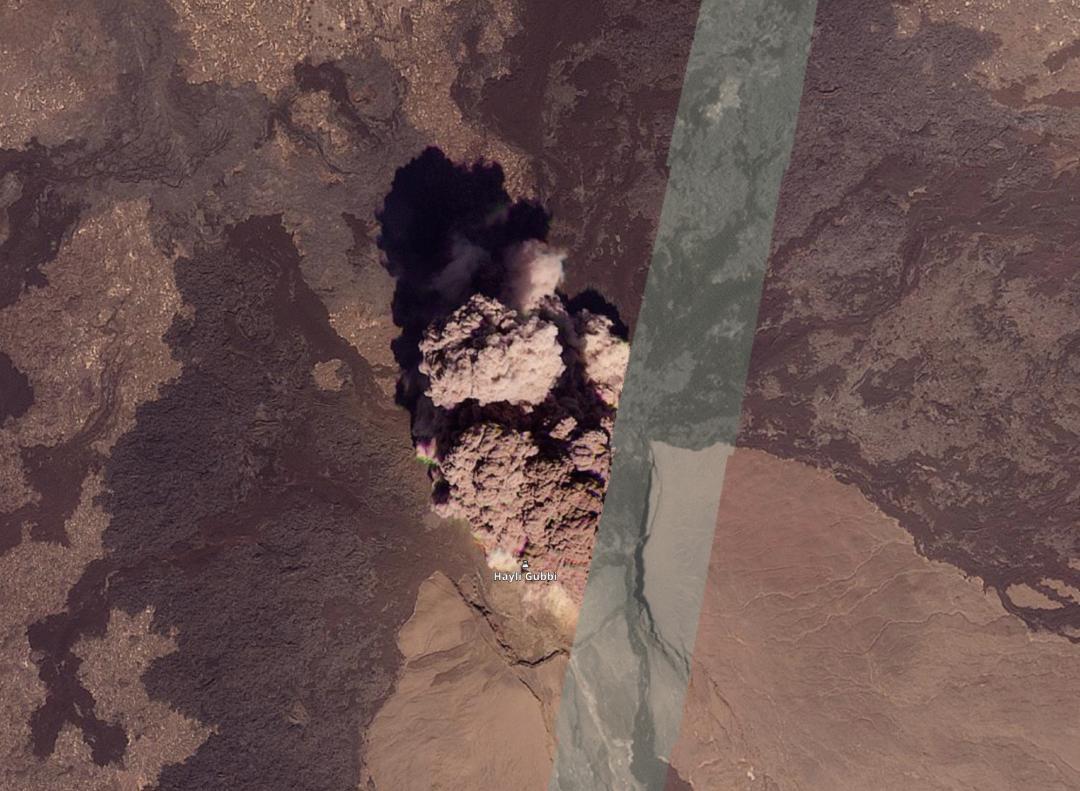
A recent satellite image has captured the breathtaking eruption of Ethiopia’s Hayli Gubbi volcano from space, providing a unique perspective on the massive volcanic event that has been making headlines around the world. The plume of volcanic ash from Ethiopia has swept across the Red Sea, passing through Oman and Yemen, and has even reached as far as India, leaving a trail of destruction and disruption in its wake.
The eruption of the Hayli Gubbi volcano, which was reported to be dormant for several thousand years, began on Sunday morning, sending an ash column thousands of feet into the atmosphere. The sheer scale and intensity of the eruption have been awe-inspiring, with the volcano’s ash cloud spreading rapidly across the region and beyond.
The satellite image, which has been widely shared on social media and news outlets, shows the volcano’s ash cloud stretching across the Red Sea, with a thick plume of ash and smoke rising high into the atmosphere. The image provides a striking visual representation of the eruption’s massive scale and its far-reaching impact on the surrounding environment.
The Hayli Gubbi volcano, located in the Afar region of Ethiopia, is one of the country’s most remote and inaccessible volcanoes. The volcano’s eruption has been described as a rare and significant event, with scientists estimating that it may have been dormant for as long as 10,000 years.
The eruption has had a significant impact on the local environment, with reports of ash fall and smoke affecting nearby communities and wildlife. The ash cloud has also disrupted air travel in the region, with several flights canceled or diverted due to the hazardous conditions.
As the ash cloud continues to spread across the region, concerns are growing about the potential impact on agriculture, water supplies, and human health. Volcanic ash can be highly toxic and can cause respiratory problems, particularly for people with pre-existing conditions.
The Ethiopian government has issued warnings to local communities and has advised people to stay indoors and avoid traveling to affected areas. The government has also deployed emergency response teams to the region to provide assistance and support to those affected by the eruption.
The eruption of the Hayli Gubbi volcano has also sparked widespread interest and fascination among scientists and volcanologists, who are eager to study the event and learn more about the volcano’s behavior and characteristics.
The use of satellite imagery has been instrumental in monitoring the eruption and tracking the movement of the ash cloud. Satellite images have provided valuable insights into the volcano’s activity, allowing scientists to monitor the eruption in real-time and provide critical information to emergency responders and policymakers.
In conclusion, the eruption of the Hayli Gubbi volcano in Ethiopia is a significant and rare event that has captivated the attention of people around the world. The satellite image of the eruption from space provides a stunning visual representation of the volcano’s power and intensity, and highlights the importance of monitoring and studying volcanic activity to better understand and prepare for such events.
As the situation continues to unfold, it is essential to stay informed and up-to-date with the latest developments and updates. The Ethiopian government and international authorities are working closely together to respond to the eruption and mitigate its impact on the environment and local communities.