IIT Bombay’s AI speeds up hurricane damage assessment
Hurricanes are one of the most destructive natural disasters, causing widespread damage to infrastructure, buildings, and the environment. Assessing the damage after a hurricane is crucial for disaster response and relief efforts. However, traditional methods of damage assessment can be time-consuming and labor-intensive, involving manual surveys and on-site inspections. Recent advancements in artificial intelligence (AI) and computer vision have paved the way for more efficient and accurate damage assessment methods.
Researchers at the Indian Institute of Technology Bombay (IIT Bombay) have developed an AI model called SpADANet, which can identify building damage from aerial images. This innovative model has the potential to revolutionize hurricane damage assessment, enabling faster and more accurate damage evaluation. In this blog post, we will delve into the details of SpADANet, its capabilities, and its potential impact on disaster response and relief efforts.
The Challenge of Hurricane Damage Assessment
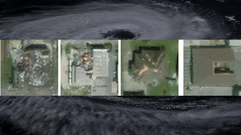
Hurricane damage assessment is a complex task that requires careful evaluation of the extent of damage to buildings, infrastructure, and other critical assets. Traditional methods of damage assessment involve manual surveys, which can be time-consuming and labor-intensive. Moreover, these methods often rely on visual inspections, which can be subjective and prone to errors. The use of aerial images, such as those captured by drones or satellites, can provide a more comprehensive view of the damage. However, analyzing these images manually can be a daunting task, requiring significant expertise and resources.
Introducing SpADANet: A Novel AI Model
SpADANet is a novel AI model developed by IIT Bombay researchers that can identify building damage from aerial images. This model is designed to overcome the “domain gap,” which refers to the difference in appearance between the training data and the actual data. In other words, SpADANet can adapt to different storms and environments with minimal data, making it a highly versatile and effective tool for damage assessment.
SpADANet uses spatial context to analyze aerial images and identify building damage. This approach enables the model to consider the relationships between different objects and features in the image, such as buildings, roads, and vegetation. By leveraging spatial context, SpADANet can outperform existing methods of damage assessment, which often rely on manual annotations and limited contextual information.
Optimized for Mobile Devices
One of the key advantages of SpADANet is its optimization for mobile devices. This means that the model can be deployed on smartphones, tablets, or other mobile devices, enabling rapid damage assessment in the field. Mobile devices are increasingly being used for disaster response and relief efforts, and SpADANet can be integrated with these devices to provide real-time damage assessments.
Improving Real-Time Disaster Response and Relief Efforts
The development of SpADANet has significant implications for real-time disaster response and relief efforts. By providing accurate and rapid damage assessments, SpADANet can help emergency responders and relief teams to prioritize their efforts, allocate resources more effectively, and save lives. Moreover, SpADANet can be used to monitor the progress of relief efforts, enabling more effective coordination and collaboration between different agencies and organizations.
Global Impact
The potential impact of SpADANet extends beyond India, with applications in hurricane-prone regions around the world. The model can be used to assess damage from other types of natural disasters, such as earthquakes, floods, and wildfires. By providing a rapid and accurate damage assessment, SpADANet can help to reduce the economic and human costs of disasters, and enable more effective disaster response and relief efforts.
Conclusion
In conclusion, SpADANet is a novel AI model developed by IIT Bombay researchers that has the potential to revolutionize hurricane damage assessment. By leveraging spatial context and adapting to different storms and environments, SpADANet can provide accurate and rapid damage assessments, enabling more effective disaster response and relief efforts. The optimization of SpADANet for mobile devices makes it a highly versatile and effective tool for damage assessment, with applications in hurricane-prone regions around the world. As we move forward, it is essential to continue developing and refining AI models like SpADANet, which can help to mitigate the impact of natural disasters and save lives.
News Source: https://researchmatters.in/news/novel-spatially-aware-ai-model-makes-hurricane-damage-assessment-more-accurate