IIT Bombay’s AI speeds up hurricane damage assessment
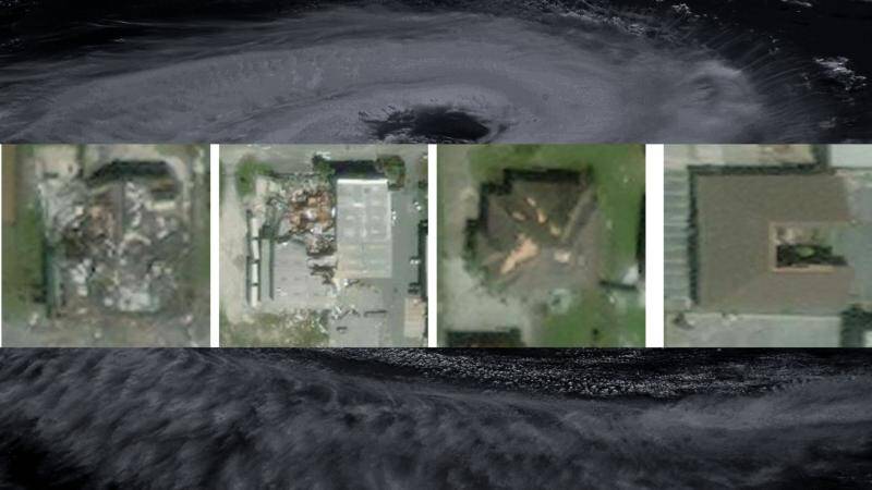
Hurricanes are one of the most destructive natural disasters, causing widespread damage to infrastructure, homes, and the environment. Assessing the extent of the damage after a hurricane is crucial for effective disaster response and relief efforts. However, traditional methods of damage assessment can be time-consuming, labor-intensive, and often inaccurate. To address this challenge, researchers at the Indian Institute of Technology (IIT) Bombay have developed an innovative AI model called SpADANet, which can quickly and accurately assess building damage from aerial images.
SpADANet is a spatially aware AI model that uses deep learning techniques to identify damaged buildings from aerial images. What makes SpADANet unique is its ability to overcome the “domain gap,” which refers to the difference in appearance between images taken during different storms. This allows the model to adapt to different storms with minimal data, making it a valuable tool for disaster response teams. The model is also optimized for mobile devices, making it accessible to a wide range of users.
The development of SpADANet is a significant breakthrough in disaster response and relief efforts. Traditional methods of damage assessment rely on manual surveys, which can be time-consuming and often require extensive resources. With SpADANet, disaster response teams can quickly assess the extent of the damage and prioritize their efforts accordingly. The model can also be used to identify areas that require immediate attention, such as buildings that are at risk of collapse or those that have suffered significant damage.
One of the key features of SpADANet is its use of spatial context to identify damaged buildings. The model takes into account the spatial relationships between buildings, roads, and other features in the aerial images. This allows it to accurately identify damaged buildings, even in areas with complex infrastructure. The model has been tested on a range of aerial images, including those taken during hurricanes in the United States and cyclones in India.
The results of the testing have been impressive, with SpADANet outperforming existing methods of damage assessment. The model has been shown to be highly accurate, with an accuracy rate of over 90% in some cases. This is significant, as it means that disaster response teams can rely on the model to provide accurate information about the extent of the damage.
The development of SpADANet has significant implications for disaster response and relief efforts globally. The model can be used to assess damage from a range of natural disasters, including hurricanes, cyclones, floods, and earthquakes. It can also be used to identify areas that are at risk of damage, allowing disaster response teams to take proactive measures to mitigate the impact of the disaster.
In addition to its use in disaster response, SpADANet has the potential to be used in a range of other applications, including urban planning and infrastructure development. The model can be used to assess the condition of buildings and infrastructure, allowing urban planners to identify areas that require maintenance or upgrading. It can also be used to monitor the impact of climate change on urban areas, allowing policymakers to develop strategies to mitigate its effects.
In conclusion, the development of SpADANet by IIT Bombay researchers is a significant breakthrough in disaster response and relief efforts. The model’s ability to quickly and accurately assess building damage from aerial images makes it a valuable tool for disaster response teams. Its use of spatial context and ability to overcome the “domain gap” make it a highly effective model, even in areas with complex infrastructure. As the world becomes increasingly vulnerable to natural disasters, the development of SpADANet is a timely reminder of the importance of innovation and technology in disaster response and relief efforts.
The potential of SpADANet to improve real-time disaster response and relief efforts globally is significant. With its ability to quickly and accurately assess damage, the model can help disaster response teams to prioritize their efforts and allocate resources more effectively. It can also be used to identify areas that require immediate attention, allowing disaster response teams to take proactive measures to mitigate the impact of the disaster.
Overall, the development of SpADANet is a significant achievement, and it has the potential to make a significant impact on disaster response and relief efforts globally. As the model continues to be developed and refined, it is likely to become an essential tool for disaster response teams, allowing them to respond more quickly and effectively to natural disasters.
News Source: https://researchmatters.in/news/novel-spatially-aware-ai-model-makes-hurricane-damage-assessment-more-accurate