First detailed look at tsunami captured from space by NASA
The field of space research has led to numerous groundbreaking discoveries, and the latest one is a significant milestone in understanding natural disasters. NASA and the French space agency CNES’s (Centre National d’Etudes Spatiales) SWOT (Surface Water and Ocean Topography) satellite have captured the first detailed look at a tsunami from space. This remarkable achievement has shed new light on the behavior of tsunamis, challenging earlier assumptions and paving the way for better disaster preparedness and mitigation strategies.
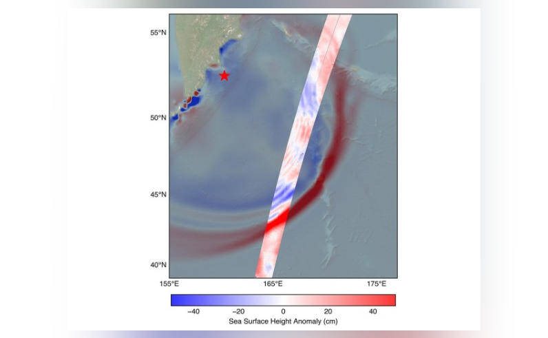
On July 30, a massive 8.8 magnitude earthquake struck off the coast of Russia’s Kamchatka peninsula, generating a tsunami that traveled across the Pacific Ocean. The SWOT satellite, launched in December 2022, was in the perfect position to track the waves generated by the earthquake. The satellite’s advanced instruments and high-resolution imaging capabilities allowed scientists to observe the tsunami in unprecedented detail, providing a unique insight into the dynamics of these powerful waves.
One of the most significant discoveries made by the SWOT satellite was that the tsunami did not maintain a single, uniform form as it traveled across the ocean. Instead, it split into multiple waves, with a large leading wave followed by smaller ones. This phenomenon, known as “wave dispersion,” has significant implications for our understanding of tsunami behavior and the potential impact on coastal communities.
The traditional view of tsunamis is that they are massive, uniform waves that maintain their shape and size as they travel across the ocean. However, the SWOT satellite’s observations reveal a more complex and dynamic picture. The leading wave, which is typically the largest and most destructive, is followed by a series of smaller waves that can still cause significant damage and flooding. This discovery challenges the earlier belief that tsunamis are single, uniform waves and highlights the need for more advanced modeling and prediction tools.
The SWOT satellite’s observations also provide valuable insights into the physics of tsunami waves. By tracking the waves’ behavior and characteristics, scientists can better understand the factors that influence their propagation and impact. This knowledge can be used to improve tsunami forecasting models, which are critical for saving lives and reducing damage to coastal infrastructure.
The implications of this discovery are far-reaching and significant. Tsunamis are among the most destructive natural disasters, capable of causing widespread devastation and loss of life. The 2004 Indian Ocean tsunami, for example, resulted in over 230,000 deaths and widespread destruction across several countries. The ability to better understand and predict tsunami behavior can help mitigate the impact of these events, saving lives and reducing economic losses.
The SWOT satellite’s achievement is also a testament to the power of international collaboration in space research. The partnership between NASA and CNES has enabled the development of advanced satellite technology, which is providing new insights into our planet’s oceans and natural systems. The SWOT mission is a prime example of how space agencies can work together to advance our understanding of the Earth and improve our ability to predict and respond to natural disasters.
In conclusion, the first detailed look at a tsunami from space, captured by NASA and CNES’s SWOT satellite, is a significant milestone in the field of space research. The discovery that tsunamis can split into multiple waves, with a large leading wave followed by smaller ones, challenges earlier assumptions and highlights the need for more advanced modeling and prediction tools. As scientists continue to study the data from the SWOT satellite, we can expect to gain a deeper understanding of tsunami behavior and improve our ability to predict and respond to these devastating events.