First Detailed Look at Tsunami Captured from Space by NASA
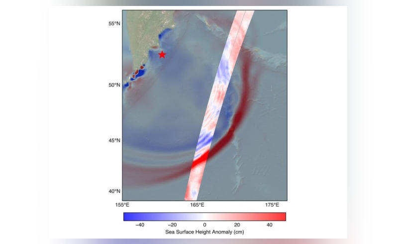
The field of oceanography has witnessed a significant breakthrough, thanks to the collaborative efforts of NASA and the French space agency, CNES (Centre National d’Etudes Spatiales). Their SWOT (Surface Water and Ocean Topography) satellite has achieved a remarkable feat by capturing the first detailed look at a tsunami from space. This groundbreaking observation was made possible when the system tracked the waves generated by an 8.8 magnitude earthquake that occurred off Russia’s Kamchatka peninsula on July 30.
The data collected by the SWOT satellite has shed new light on the behavior of tsunamis, challenging the earlier belief that these massive waves maintain a single, uniform form as they travel across the ocean. Instead, scientists discovered that the tsunami split into multiple waves, with a large leading wave followed by smaller ones. This revelation has significant implications for our understanding of tsunami dynamics and the development of more accurate early warning systems.
To grasp the importance of this discovery, it’s essential to understand the basics of tsunamis. A tsunami is a series of ocean waves that are caused by the displacement of a large volume of water, usually as a result of an earthquake or volcanic eruption. The energy released by these events can generate waves that reach heights of over 100 feet, traveling at speeds of up to 500 miles per hour. The impact of a tsunami can be devastating, causing widespread destruction and loss of life when it reaches the coastline.
The SWOT satellite, launched in December 2022, is equipped with advanced radar technology that enables it to measure the height of the ocean surface with unprecedented accuracy. This capability allows scientists to track the movement of tsunamis in real-time, providing valuable insights into their behavior and characteristics. By analyzing the data collected by the SWOT satellite, researchers can gain a better understanding of how tsunamis propagate and interact with the ocean and coastline.
The observation of the tsunami waves splitting into multiple waves is a significant finding, as it challenges the traditional view of tsunamis as a single, uniform wave. This new information can be used to improve the accuracy of tsunami forecasting models, which are critical for issuing timely warnings and evacuating people from affected areas. By understanding the complex behavior of tsunamis, scientists can develop more effective strategies for mitigating the impact of these events and saving lives.
The implications of this discovery extend beyond the field of oceanography, with potential applications in the development of more resilient coastal infrastructure and emergency response planning. By understanding the dynamics of tsunamis, engineers and urban planners can design more effective seawalls, breakwaters, and other coastal protection measures to reduce the risk of damage and flooding.
The collaboration between NASA and CNES on the SWOT satellite is a testament to the power of international cooperation in advancing our understanding of the Earth’s oceans. The mission has brought together scientists and engineers from around the world to study the ocean’s surface and subsurface, with a focus on understanding the complex interactions between the ocean, atmosphere, and land.
As the SWOT satellite continues to collect data and provide new insights into the behavior of tsunamis, scientists are eager to explore the full potential of this technology. With its advanced radar capabilities and global coverage, the SWOT satellite is poised to revolutionize our understanding of the ocean and its role in shaping our planet.
In conclusion, the first detailed look at a tsunami captured from space by NASA and CNES’s SWOT satellite is a significant breakthrough in the field of oceanography. The discovery of tsunami waves splitting into multiple waves challenges our earlier understanding of these events and has important implications for the development of more accurate early warning systems and resilient coastal infrastructure. As we continue to explore the complexities of the ocean and its interactions with the Earth’s systems, we are reminded of the importance of international cooperation and the power of scientific discovery in advancing our knowledge and protecting our planet.