First Detailed Look at Tsunami Captured from Space by NASA
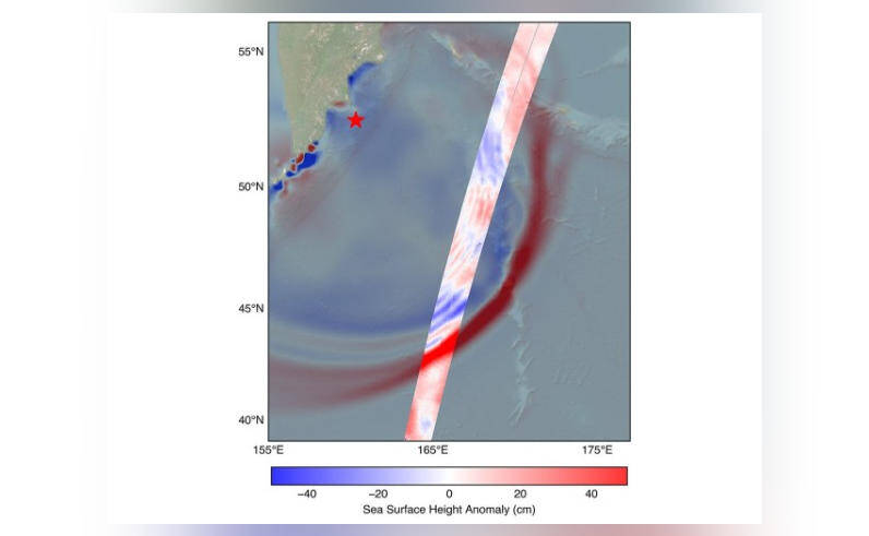
In a groundbreaking achievement, NASA and the French space agency CNES’s (Centre National d’Etudes Spatiales) SWOT (Surface Water and Ocean Topography) satellite has captured the first detailed look at a tsunami from space. This remarkable feat was made possible when the system tracked the waves generated by the 8.8 magnitude earthquake off Russia’s Kamchatka peninsula on July 30. The data collected by the SWOT satellite has provided scientists with a new understanding of tsunami behavior, challenging earlier beliefs about these powerful ocean waves.
The SWOT satellite, launched in December 2022, is designed to study the world’s oceans and surface water. Equipped with advanced instruments, including a radar interferometer and a lidar (light detection and ranging) instrument, the satellite is capable of measuring the height of the ocean surface with unprecedented accuracy. This capability has allowed scientists to track the movement of tsunamis in real-time, providing valuable insights into their behavior.
The 8.8 magnitude earthquake that struck off Russia’s Kamchatka peninsula on July 30 generated a tsunami that traveled across the Pacific Ocean. The SWOT satellite, orbiting the Earth at an altitude of approximately 890 kilometers, detected the tsunami waves and began tracking their movement. The data collected by the satellite revealed that the tsunami did not behave as previously thought. Instead of maintaining a single, uniform form, the tsunami split into multiple waves, with a large leading wave followed by smaller ones.
This discovery challenges the earlier belief that tsunamis maintain a consistent shape and size as they travel across the ocean. The new data suggests that tsunamis are more complex and dynamic than previously thought, with the potential to change shape and size as they interact with the ocean floor and surrounding water. This knowledge is crucial for improving tsunami forecasting and warning systems, which rely on accurate predictions of tsunami behavior to save lives and prevent damage.
The SWOT satellite’s ability to track tsunamis in real-time has significant implications for disaster preparedness and response. By providing detailed information about the size, shape, and movement of tsunami waves, the satellite can help scientists and emergency responders to better understand the potential impact of a tsunami and take necessary precautions to mitigate its effects. This can include evacuating coastal areas, securing ports and harbors, and protecting critical infrastructure.
The data collected by the SWOT satellite will also contribute to a better understanding of the underlying mechanisms that drive tsunami behavior. By studying the interaction between the tsunami waves and the ocean floor, scientists can gain insights into the factors that influence the size and shape of tsunamis, such as the depth and topography of the ocean floor, the distance from the earthquake epicenter, and the properties of the surrounding water.
The partnership between NASA and CNES has been instrumental in the development and launch of the SWOT satellite. The two space agencies have a long history of collaboration on Earth science missions, and the SWOT satellite is a prime example of the benefits of international cooperation in space exploration. By working together, NASA and CNES have been able to pool their resources and expertise to develop a cutting-edge satellite that is providing unprecedented insights into the world’s oceans and surface water.
In conclusion, the SWOT satellite’s capture of the first detailed look at a tsunami from space is a significant achievement that has the potential to revolutionize our understanding of these powerful ocean waves. By providing real-time data on tsunami behavior, the satellite can help scientists and emergency responders to better prepare for and respond to tsunami events, saving lives and preventing damage. As the SWOT satellite continues to orbit the Earth, it will provide a wealth of new information about the world’s oceans and surface water, helping us to better understand and protect our planet.