First detailed look at tsunami captured from space by NASA
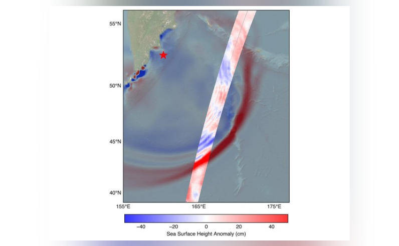
The field of natural disaster monitoring has taken a significant leap forward with the help of NASA and the French space agency CNES’s SWOT (Surface Water and Ocean Topography) satellite. For the first time, the satellite has captured a detailed look at a tsunami from space, providing scientists with invaluable insights into the behavior of these massive ocean waves. The system tracked the waves generated by the 8.8 magnitude earthquake that struck off Russia’s Kamchatka peninsula on July 30, revealing fascinating details about the nature of tsunamis.
The SWOT satellite, launched in December 2022, is equipped with advanced radar technology that allows it to measure the height of the ocean surface with unprecedented accuracy. This capability has enabled scientists to study the dynamics of tsunamis in greater detail than ever before. The recent observation of the tsunami waves off Kamchatka has challenged earlier beliefs about the behavior of tsunamis, shedding new light on the complex processes that drive these powerful waves.
One of the most significant discoveries made by the SWOT satellite is that the tsunami did not maintain a single, uniform form as it traveled across the ocean. Instead, the satellite observed that the tsunami split into multiple waves, with a large leading wave followed by smaller ones. This phenomenon, known as “wave dispersion,” is a well-known characteristic of ocean waves, but its occurrence in tsunamis had not been previously observed in such detail.
The implications of this discovery are significant, as it challenges the traditional view of tsunamis as a single, monolithic wave. The observation of multiple waves with varying amplitudes and wavelengths suggests that tsunamis are more complex and dynamic than previously thought. This new understanding of tsunami behavior could have important implications for tsunami prediction and warning systems, as it may allow scientists to better forecast the impact of these waves on coastal communities.
The SWOT satellite’s observation of the tsunami also provided valuable insights into the wave’s speed and direction. The satellite tracked the wave as it traveled across the ocean at a speed of approximately 500 miles per hour, which is consistent with the expected speed of a tsunami wave. The satellite also observed that the wave changed direction as it interacted with the ocean floor and surrounding coastlines, highlighting the complex interactions between the wave and its environment.
The ability to observe tsunamis from space is a significant breakthrough in the field of natural disaster monitoring. Traditional methods of monitoring tsunamis rely on a network of buoys and coastal sensors, which can provide limited information about the wave’s behavior. The SWOT satellite’s advanced radar technology offers a more comprehensive view of the wave’s dynamics, allowing scientists to study the wave’s behavior in greater detail and over larger distances.
The potential applications of this technology are vast, ranging from improved tsunami prediction and warning systems to enhanced monitoring of ocean currents and coastal erosion. The SWOT satellite’s observations could also contribute to a better understanding of the impact of climate change on ocean dynamics and the frequency and severity of natural disasters.
In conclusion, the SWOT satellite’s capture of a detailed look at a tsunami from space marks a significant milestone in the field of natural disaster monitoring. The observation of multiple waves with varying amplitudes and wavelengths challenges our traditional understanding of tsunamis and highlights the complex dynamics of these powerful waves. As scientists continue to analyze the data from the SWOT satellite, we can expect to gain a deeper understanding of tsunamis and their behavior, ultimately leading to improved prediction and warning systems that can help save lives and reduce the impact of these devastating events.