First Detailed Look at Tsunami Captured from Space by NASA
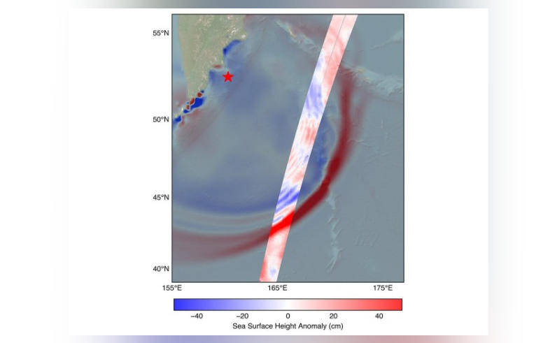
In a groundbreaking achievement, NASA and the French space agency CNES’s (Centre National d’Etudes Spatiales) SWOT (Surface Water and Ocean Topography) satellite has captured the first detailed look at a tsunami from space. The satellite tracked the waves generated by the 8.8 magnitude earthquake that struck off Russia’s Kamchatka peninsula on July 30. This remarkable observation has provided scientists with a unique insight into the behavior of tsunamis, challenging earlier beliefs about their formation and propagation.
The SWOT satellite, launched in December 2022, is designed to study the world’s oceans, lakes, and rivers. Equipped with advanced radar and lidar instruments, it can measure the height of water surfaces with unprecedented accuracy. On July 30, the satellite was in the right position to capture the tsunami waves generated by the powerful earthquake off the Kamchatka peninsula. The data collected by SWOT has revealed a complex and dynamic picture of the tsunami, which is revolutionizing our understanding of these massive ocean waves.
One of the most significant discoveries made by the SWOT satellite is that the tsunami did not maintain a single, uniform form as it traveled across the ocean. Instead, it split into multiple waves, with a large leading wave followed by smaller ones. This challenges the earlier belief that tsunamis are characterized by a single, massive wave that maintains its shape and size as it propagates. The new findings suggest that tsunamis are more complex and dynamic than previously thought, with multiple waves interacting and influencing each other.
The SWOT satellite’s observations have also provided valuable insights into the speed and direction of the tsunami waves. The data shows that the waves traveled at speeds of up to 500 miles per hour, which is consistent with earlier estimates. However, the satellite’s high-resolution measurements also revealed subtle changes in the wave’s direction and speed as it interacted with the ocean floor and surrounding coastline.
The implications of this discovery are significant, as it can help improve tsunami forecasting and warning systems. By understanding the complex behavior of tsunamis, scientists can develop more accurate models to predict the impact of these events on coastal communities. This can help save lives and reduce the damage caused by tsunamis, which can have devastating effects on coastal ecosystems and human populations.
The SWOT satellite’s achievement is also a testament to the power of international collaboration in space exploration. The satellite is a joint mission between NASA and CNES, with contributions from other space agencies and research institutions around the world. The success of the SWOT mission demonstrates the importance of cooperation and knowledge-sharing in advancing our understanding of the Earth’s oceans and natural systems.
In conclusion, the SWOT satellite’s capture of the first detailed look at a tsunami from space is a groundbreaking achievement that has significant implications for our understanding of these powerful ocean waves. The discovery that tsunamis can split into multiple waves challenges earlier beliefs and provides new insights into their behavior and propagation. As scientists continue to analyze the data collected by the SWOT satellite, we can expect to learn more about the complex dynamics of tsunamis and how to better predict and prepare for these events.