First detailed look at tsunami captured from space by NASA
The world of science has witnessed a groundbreaking moment, as NASA and the French space agency CNES’s SWOT (Surface Water and Ocean Topography) satellite have captured the first detailed look of a tsunami from space. This unprecedented achievement has provided scientists with a unique opportunity to study the behavior of these massive waves, challenging earlier beliefs and shedding new light on the dynamics of tsunamis.
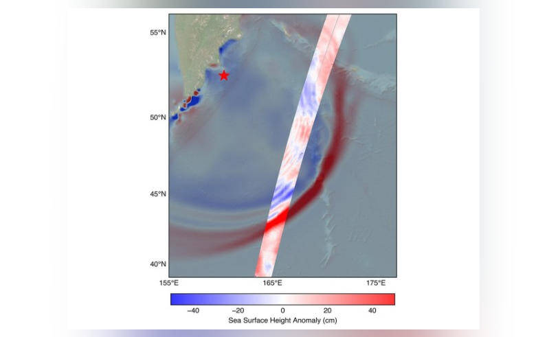
On July 30, a powerful 8.8 magnitude earthquake struck off the coast of Russia’s Kamchatka peninsula, generating a tsunami that traveled across the Pacific Ocean. The SWOT satellite, launched in December 2022, was in the perfect position to track the waves generated by the earthquake. The satellite’s advanced instruments and high-resolution imaging capabilities allowed scientists to capture the tsunami’s movement in extraordinary detail, providing a level of insight that was previously impossible to achieve.
One of the most significant discoveries made by the scientists analyzing the SWOT satellite data was that the tsunami did not maintain a single, uniform form as it traveled across the ocean. Instead, the wave split into multiple waves, with a large leading wave followed by smaller ones. This challenges the earlier belief that tsunamis maintain a consistent shape and size as they propagate. The discovery of this complex wave behavior has significant implications for our understanding of tsunamis and how they interact with the ocean and coastlines.
The SWOT satellite’s data revealed that the leading wave was followed by a series of smaller waves, often referred to as “secondary waves” or “dispersive waves.” These secondary waves were found to be traveling at different speeds and had varying amplitudes, which affected the overall shape and behavior of the tsunami. This complex wave behavior is thought to be influenced by a range of factors, including the shape of the seafloor, the depth of the ocean, and the properties of the water itself.
The ability to study tsunamis in such detail from space is a major breakthrough, as it allows scientists to gain a better understanding of these powerful waves and how they impact coastal communities. Tsunamis are a significant threat to people living in low-lying areas, and being able to predict their behavior and impact is crucial for saving lives and reducing damage to infrastructure.
The SWOT satellite’s mission is to study the world’s oceans and surface water, with a focus on understanding the dynamics of the ocean and its role in the Earth’s climate system. The satellite is equipped with advanced instruments, including a radar interferometer and a lidar (light detection and ranging) system, which allow it to map the ocean’s surface topography with unprecedented accuracy.
The data collected by the SWOT satellite will be used to improve our understanding of the ocean’s role in the Earth’s climate system, including the movement of heat and nutrients across the globe. The satellite will also provide valuable insights into the impact of climate change on the ocean and its ecosystems, including the effects of sea level rise, ocean acidification, and changes in ocean circulation patterns.
In addition to its scientific significance, the SWOT satellite’s ability to track tsunamis from space has important practical applications. By providing early warnings of tsunami events, the satellite can help save lives and reduce the impact of these disasters on coastal communities. The satellite’s data can also be used to improve the design and construction of coastal infrastructure, such as seawalls and breakwaters, which can help mitigate the effects of tsunamis.
In conclusion, the SWOT satellite’s capture of the first detailed look at a tsunami from space is a major milestone in the field of oceanography and disaster management. The discovery of the complex wave behavior of tsunamis challenges earlier beliefs and provides new insights into the dynamics of these powerful waves. As scientists continue to analyze the data collected by the SWOT satellite, we can expect to gain a deeper understanding of the ocean and its role in the Earth’s climate system, as well as improve our ability to predict and prepare for tsunami events.