First Detailed Look at Tsunami Captured from Space by NASA
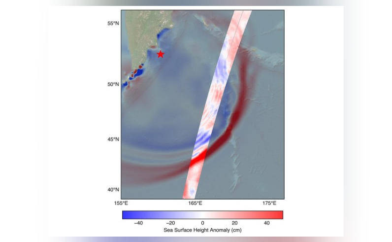
In a groundbreaking achievement, NASA and the French space agency CNES’s SWOT (Surface Water and Ocean Topography) satellite have successfully captured the first detailed look of a tsunami from space. The system tracked the waves generated by the 8.8 magnitude earthquake off Russia’s Kamchatka peninsula on July 30, providing unprecedented insights into the behavior of these massive ocean waves. This breakthrough discovery challenges the earlier belief that tsunamis maintain a single, uniform form, and instead, reveals a more complex and dynamic phenomenon.
The SWOT satellite, launched in December 2022, is designed to study the world’s oceans and surface water bodies with unprecedented accuracy. Equipped with advanced radar and lidar instruments, the satellite can measure the height of the ocean surface with a precision of just a few centimeters. This capability allows scientists to track even the slightest changes in ocean topography, including the formation and propagation of tsunamis.
On July 30, a powerful earthquake struck off the coast of Russia’s Kamchatka peninsula, triggering a tsunami that traveled across the Pacific Ocean. The SWOT satellite, orbiting the Earth at an altitude of around 900 kilometers, detected the tsunami waves and began tracking their movement. The satellite’s instruments captured the tsunami’s evolution, from its initial formation to its propagation across the ocean, providing a detailed and comprehensive picture of the event.
The data collected by the SWOT satellite revealed a surprising phenomenon – the tsunami did not maintain a single, uniform form as previously thought. Instead, it split into multiple waves, with a large leading wave followed by smaller ones. This complex behavior challenges the traditional understanding of tsunamis and highlights the need for further research into the dynamics of these powerful ocean waves.
The discovery has significant implications for tsunami warning systems and coastal protection measures. Traditional tsunami models assume a single, uniform wave, which can lead to inaccurate predictions of wave amplitude and arrival time. By recognizing the complex and dynamic nature of tsunamis, scientists can develop more accurate models and warning systems, ultimately saving lives and reducing damage to coastal communities.
The SWOT satellite’s ability to track tsunamis from space also opens up new possibilities for real-time monitoring and prediction. By providing detailed information on tsunami wave height, direction, and speed, the satellite can help scientists and emergency responders to quickly assess the situation and take necessary actions to protect coastal areas.
The successful capture of the tsunami by the SWOT satellite is a testament to the power of space-based technology in understanding our planet’s oceans. The mission demonstrates the potential of satellites to provide critical information on ocean dynamics, which is essential for predicting and mitigating the impacts of natural disasters like tsunamis.
In conclusion, the first detailed look at a tsunami captured from space by NASA and CNES’s SWOT satellite is a groundbreaking achievement that challenges our understanding of these powerful ocean waves. The discovery of multiple waves and complex behavior highlights the need for further research and improved models for tsunami prediction and warning systems. As the SWOT satellite continues to orbit the Earth, it is likely to provide many more insights into the dynamics of our oceans, ultimately helping to protect coastal communities and save lives.