First Detailed Look at Tsunami Captured from Space by NASA
The field of space exploration and disaster monitoring has taken a significant leap forward, thanks to the innovative technology and collaborative efforts of NASA and the French space agency, CNES (Centre National d’Etudes Spatiales). Their SWOT (Surface Water and Ocean Topography) satellite has achieved a groundbreaking feat by capturing the first detailed look at a tsunami from space. This remarkable achievement has not only expanded our understanding of these powerful natural disasters but also has the potential to revolutionize the way we monitor and predict tsunamis, ultimately saving countless lives.
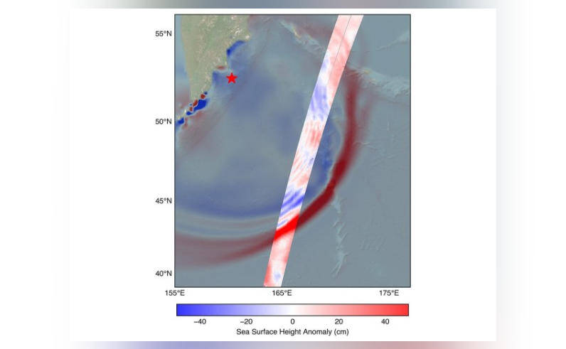
On July 30, a massive 8.8 magnitude earthquake struck off the coast of Russia’s Kamchatka peninsula, triggering a tsunami that traveled across the Pacific Ocean. The SWOT satellite, launched in December 2022, was in the perfect position to track the waves generated by this powerful seismic event. The satellite’s advanced radar technology allowed scientists to observe the tsunami in unprecedented detail, providing valuable insights into its behavior and characteristics.
One of the most significant discoveries made by the SWOT satellite was that the tsunami did not maintain a single, uniform form as it traveled across the ocean. Instead, it split into multiple waves, with a large leading wave followed by smaller ones. This challenges the earlier belief that tsunamis typically maintain a consistent shape and size as they propagate. This new information has important implications for tsunami forecasting and warning systems, as it suggests that the impact of a tsunami can be more complex and variable than previously thought.
The SWOT satellite’s ability to capture high-resolution images of the ocean surface has also revealed the complex interactions between the tsunami waves and the ocean’s topography. Scientists were able to observe how the waves interacted with underwater features such as seamounts and ridges, causing the tsunami to change direction and amplitude. This level of detail has never been seen before and will be invaluable for improving tsunami modeling and prediction.
The implications of this discovery are far-reaching and have the potential to save countless lives. Tsunamis are one of the most destructive and deadly natural disasters, causing widespread devastation and loss of life. The ability to accurately predict the behavior and impact of a tsunami is crucial for evacuating people from affected areas and minimizing damage to infrastructure. The data collected by the SWOT satellite will be used to improve tsunami forecasting models, enabling scientists to provide more accurate and timely warnings to communities at risk.
The SWOT satellite is a game-changer in the field of oceanography and disaster monitoring. Its advanced technology and ability to capture high-resolution images of the ocean surface have opened up new possibilities for studying the Earth’s oceans and monitoring natural disasters. The satellite’s data will be used to study a wide range of phenomena, from ocean currents and tides to ocean floor topography and the impact of climate change on the oceans.
The collaboration between NASA and CNES on the SWOT mission is a testament to the power of international cooperation in advancing our understanding of the Earth and its natural systems. The mission has brought together scientists and engineers from around the world, sharing their expertise and resources to achieve a common goal. The success of the SWOT mission is a shining example of what can be achieved when nations and organizations work together to advance our knowledge and understanding of the Earth and its natural systems.
In conclusion, the first detailed look at a tsunami captured from space by NASA and CNES’s SWOT satellite is a groundbreaking achievement that has the potential to revolutionize our understanding of these powerful natural disasters. The discovery that tsunamis can split into multiple waves, challenging the earlier belief that they maintain a single, uniform form, has important implications for tsunami forecasting and warning systems. The data collected by the SWOT satellite will be used to improve tsunami modeling and prediction, ultimately saving countless lives. As we continue to explore and monitor the Earth’s oceans, we are reminded of the importance of international cooperation and the power of advanced technology in advancing our knowledge and understanding of the Earth and its natural systems.