First Detailed Look at Tsunami Captured from Space by NASA
The field of space exploration and satellite technology has led to numerous groundbreaking discoveries, and the latest one is a significant milestone in understanding one of the most powerful and destructive natural phenomena – tsunamis. NASA and the French space agency CNES’s (Centre National d’Etudes Spatiales) SWOT (Surface Water and Ocean Topography) satellite have achieved a remarkable feat by capturing the first detailed look at a tsunami from space. This unprecedented observation has provided scientists with a wealth of new information, challenging earlier beliefs about the behavior of tsunamis.
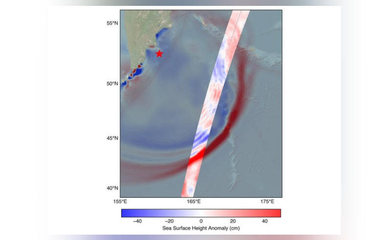
On July 30, a massive 8.8 magnitude earthquake struck off the coast of Russia’s Kamchatka peninsula, triggering a tsunami that traveled across the Pacific Ocean. The SWOT satellite, launched in December 2022, was in the perfect position to track the waves generated by the earthquake. The satellite’s advanced instruments and high-resolution imaging capabilities allowed scientists to observe the tsunami in unprecedented detail, providing a unique insight into the behavior of these powerful waves.
The data collected by the SWOT satellite revealed that the tsunami did not maintain a single, uniform form as previously believed. Instead, it split into multiple waves, with a large leading wave followed by smaller ones. This discovery has significant implications for our understanding of tsunami dynamics and the potential impact on coastal communities.
Challenging Earlier Beliefs
The traditional view of tsunamis is that they are large, uniform waves that travel at a constant speed. However, the SWOT satellite’s observations suggest that this is not always the case. The data showed that the tsunami waves were more complex and dynamic, with multiple waves interacting and influencing each other. This complexity can affect the way tsunamis interact with coastlines, leading to varying levels of destruction and impact.
The discovery of multiple waves also raises questions about the current methods used to predict tsunami behavior. Most prediction models assume a single, uniform wave, which may not accurately reflect the complexity of real-world tsunamis. The new data from the SWOT satellite will help scientists to refine these models, leading to more accurate predictions and better preparedness for coastal communities.
The SWOT Satellite
The SWOT satellite is a joint mission between NASA and CNES, designed to study the Earth’s oceans and surface water. The satellite is equipped with advanced instruments, including a radar interferometer, a radiometer, and a lidar (light detection and ranging) system. These instruments allow the satellite to collect high-resolution data on ocean topography, sea level, and surface currents.
The SWOT satellite’s primary mission is to study the Earth’s oceans and surface water, with a focus on understanding the dynamics of the ocean and its impact on the climate. The satellite’s data will help scientists to better understand ocean currents, sea level rise, and the effects of climate change on the ocean. The satellite’s observation of the tsunami is a significant bonus, providing a unique insight into one of the most powerful and destructive natural phenomena.
Implications for Tsunami Prediction and Preparedness
The discovery of multiple waves and the complexity of tsunami behavior has significant implications for tsunami prediction and preparedness. The new data from the SWOT satellite will help scientists to refine prediction models, leading to more accurate forecasts and better preparedness for coastal communities.
The observation of the tsunami from space also highlights the importance of satellite technology in monitoring and tracking natural disasters. Satellites like SWOT provide a unique perspective on the Earth’s surface, allowing scientists to study phenomena that are difficult or impossible to observe from the ground.
Conclusion
The first detailed look at a tsunami from space, captured by the SWOT satellite, is a significant milestone in our understanding of these powerful and destructive natural phenomena. The discovery of multiple waves and the complexity of tsunami behavior challenges earlier beliefs and highlights the need for more accurate prediction models. The SWOT satellite’s observation of the tsunami demonstrates the importance of satellite technology in monitoring and tracking natural disasters, and the potential for new discoveries and insights into the Earth’s oceans and surface water.
As scientists continue to study the data from the SWOT satellite, we can expect to learn more about the behavior of tsunamis and the impact of climate change on the ocean. The new information will help to improve prediction models, leading to better preparedness and response to these devastating events. The first detailed look at a tsunami from space is just the beginning of a new era in tsunami research, and we can expect to see many more exciting discoveries in the years to come.