First detailed look at tsunami captured from space by NASA
The Earth’s oceans have long been a source of fascination and fear for humans, with their immense power and unpredictability. One of the most destructive and awe-inspiring phenomena to emerge from the oceans is the tsunami, a massive wave caused by earthquakes, landslides, or volcanic eruptions that can wreak havoc on coastal communities. For the first time, NASA and the French space agency CNES’s SWOT (Surface Water and Ocean Topography) satellite have captured a detailed look at a tsunami from space, providing scientists with a unique perspective on these powerful events.
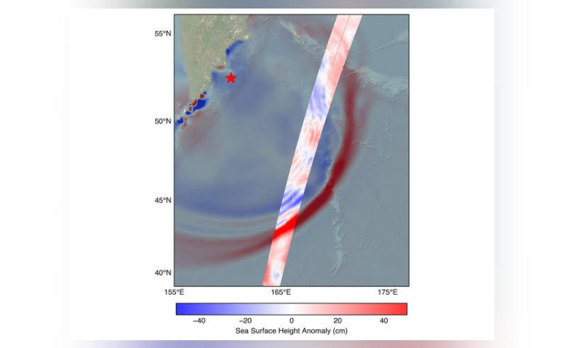
On July 30, a massive 8.8 magnitude earthquake struck off the coast of Russia’s Kamchatka peninsula, generating a tsunami that traveled across the Pacific Ocean. The SWOT satellite, launched in December 2022, was in the perfect position to track the waves generated by the earthquake. Using its advanced radar and lidar instruments, the satellite captured high-resolution images of the tsunami, revealing a complex and dynamic system that challenges our earlier understanding of these events.
One of the most significant discoveries made by the SWOT satellite was that the tsunami did not maintain a single, uniform form as it traveled across the ocean. Instead, the wave split into multiple smaller waves, with a large leading wave followed by a series of smaller ones. This phenomenon, known as “wave dispersion,” had been predicted by scientists but never directly observed before. The discovery has significant implications for our understanding of tsunami behavior and the development of early warning systems.
The SWOT satellite’s observations of the tsunami also revealed the importance of ocean currents and sea floor topography in shaping the wave’s behavior. As the tsunami traveled across the ocean, it interacted with ocean currents and underwater features, causing the wave to change direction and amplitude. This complex interaction between the tsunami and the ocean environment highlights the need for more advanced modeling and prediction tools to accurately forecast the impact of these events.
The capture of the tsunami from space is a significant milestone in the study of these events, and it has the potential to revolutionize our understanding of ocean dynamics and the impact of natural disasters on coastal communities. The SWOT satellite’s advanced instruments and high-resolution imaging capabilities provide a unique perspective on the ocean, allowing scientists to study the complex interactions between the ocean, atmosphere, and land in unprecedented detail.
The implications of this discovery are far-reaching, with potential applications in fields such as oceanography, geology, and emergency management. By improving our understanding of tsunami behavior and the factors that influence their impact, scientists can develop more effective early warning systems and mitigation strategies to protect coastal communities. The SWOT satellite’s observations also highlight the importance of international cooperation and collaboration in the study of natural disasters, as scientists from around the world work together to better understand and predict these events.
In conclusion, the first detailed look at a tsunami from space, captured by NASA and CNES’s SWOT satellite, is a significant breakthrough in our understanding of these powerful events. The discovery of wave dispersion and the complex interaction between the tsunami and the ocean environment highlights the need for more advanced modeling and prediction tools to accurately forecast the impact of tsunamis. As scientists continue to study the data from the SWOT satellite, we can expect to gain a deeper understanding of ocean dynamics and the factors that influence the behavior of tsunamis, ultimately leading to more effective mitigation strategies and improved protection for coastal communities.