First detailed look at tsunami captured from space by NASA
The field of space exploration and Earth observation has made tremendous progress in recent years, with satellites playing a crucial role in monitoring our planet’s natural phenomena. One such significant breakthrough has been achieved by NASA and the French space agency, CNES, with their SWOT (Surface Water and Ocean Topography) satellite. In a groundbreaking feat, the satellite has captured the first detailed look at a tsunami from space, providing unprecedented insights into these powerful and destructive events.
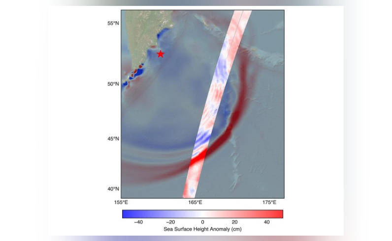
On July 30, a massive 8.8 magnitude earthquake struck off the coast of Russia’s Kamchatka peninsula, generating a tsunami that traveled across the Pacific Ocean. The SWOT satellite, launched in December 2022, was in the perfect position to track the waves generated by the earthquake. The satellite’s advanced instruments and high-resolution imaging capabilities allowed scientists to observe the tsunami in unprecedented detail, revealing new information about the behavior of these oceanic phenomena.
One of the most significant discoveries made by the SWOT satellite was that the tsunami did not maintain a single, uniform form as it traveled across the ocean. Instead, the waves split into multiple waves, with a large leading wave followed by smaller ones. This challenges the earlier belief that tsunamis maintain a consistent shape and size as they propagate. The satellite’s data showed that the leading wave was the largest and most energetic, with the smaller waves trailing behind it.
This new information has significant implications for our understanding of tsunamis and their impact on coastal communities. By studying the behavior of tsunamis in greater detail, scientists can improve their predictive models and provide more accurate warnings to people in the path of these destructive events. The SWOT satellite’s observations also highlight the importance of continued investment in Earth observation and space exploration, as these technologies can provide critical insights into our planet’s natural systems.
The SWOT satellite is equipped with a range of advanced instruments, including a radar interferometer and a lidar (light detection and ranging) system. These instruments allow the satellite to measure the height and shape of the ocean surface with unprecedented accuracy, providing detailed information about ocean currents, waves, and other phenomena. The satellite’s high-resolution imaging capabilities also enable scientists to study the ocean’s surface in great detail, revealing features such as ocean eddies, fronts, and other complex processes.
The study of tsunamis is a critical area of research, as these events can have devastating impacts on coastal communities. Tsunamis are large ocean waves caused by the displacement of a significant volume of water, usually as a result of an earthquake or volcanic eruption. They can travel at speeds of up to 500 miles per hour and reach heights of over 100 feet, causing widespread destruction and loss of life.
The SWOT satellite’s observations of the tsunami provide a unique opportunity for scientists to study these events in greater detail. By analyzing the satellite’s data, researchers can gain a better understanding of the dynamics of tsunamis, including how they form, propagate, and interact with the ocean and coastal environments. This information can be used to improve predictive models and warning systems, ultimately saving lives and reducing the impact of these destructive events.
In addition to its implications for tsunami research, the SWOT satellite’s observations also highlight the importance of international collaboration in space exploration and Earth observation. The satellite is a joint mission between NASA and CNES, with contributions from other international partners. The success of the SWOT satellite demonstrates the value of collaboration and cooperation in achieving common goals and advancing our understanding of the Earth and its systems.
In conclusion, the SWOT satellite’s capture of the first detailed look at a tsunami from space is a significant breakthrough in the field of Earth observation and space exploration. The satellite’s advanced instruments and high-resolution imaging capabilities have provided unprecedented insights into the behavior of tsunamis, challenging earlier beliefs and highlighting the importance of continued investment in these technologies. As scientists continue to analyze the satellite’s data, we can expect to gain a deeper understanding of these complex and destructive events, ultimately leading to improved predictive models and warning systems.