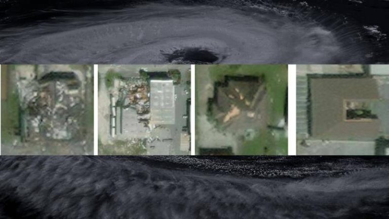
IIT Bombay’s AI speeds up hurricane damage assessment
Hurricanes are one of the most devastating natural disasters, causing widespread destruction and loss of life. The aftermath of a hurricane is a critical period, where timely assessment of damage is essential for effective disaster response and relief efforts. However, traditional methods of damage assessment can be time-consuming, labor-intensive, and often inaccurate. To address this challenge, researchers at the Indian Institute of Technology (IIT) Bombay have developed an innovative Artificial Intelligence (AI) model called SpADANet, which can quickly and accurately identify building damage from aerial images.
The SpADANet model is a significant breakthrough in the field of disaster response, as it overcomes the “domain gap” that has limited the effectiveness of existing AI models. The domain gap refers to the difference in data distribution between the training dataset and the actual data collected during a disaster. This gap can lead to poor performance of AI models in real-world scenarios. SpADANet, on the other hand, can adapt to different storms and environments with minimal data, making it a valuable tool for disaster response teams.
One of the key features of SpADANet is its ability to use spatial context to identify building damage. The model takes into account the spatial relationships between buildings, roads, and other infrastructure, allowing it to better understand the context of the damage. This approach enables SpADANet to outperform existing methods, which rely solely on visual features. The model is also optimized for mobile devices, making it accessible to disaster response teams in the field.
The development of SpADANet is a significant advancement in the field of disaster response, as it has the potential to revolutionize the way damage assessment is conducted. Traditional methods of damage assessment involve sending teams of surveyors to affected areas, which can be time-consuming and dangerous. SpADANet, on the other hand, can quickly analyze aerial images and provide accurate assessments of building damage, allowing disaster response teams to prioritize their efforts and allocate resources more effectively.
The impact of SpADANet can be significant, particularly in areas where hurricanes are frequent and devastating. For example, in the United States, hurricanes have caused billions of dollars in damage and loss of life in recent years. SpADANet can help reduce the risk of injury and death by quickly identifying areas of greatest need and allowing disaster response teams to respond more effectively.
The development of SpADANet is also a testament to the power of AI in solving real-world problems. AI has the potential to transform a wide range of fields, from healthcare and finance to education and environmental conservation. In the context of disaster response, AI can help save lives, reduce damage, and improve the overall effectiveness of relief efforts.
In addition to its potential applications in disaster response, SpADANet also has implications for urban planning and development. By analyzing aerial images and identifying patterns of damage, SpADANet can help urban planners and policymakers develop more resilient and sustainable infrastructure. This can include designing buildings and roads that are better able to withstand natural disasters, as well as developing more effective emergency response systems.
The development of SpADANet is a significant achievement for IIT Bombay, which has established itself as a leader in AI research and development. The institute has a strong track record of innovation and entrepreneurship, and its researchers are committed to using technology to solve real-world problems.
In conclusion, SpADANet is a groundbreaking AI model that has the potential to revolutionize the way damage assessment is conducted in the aftermath of a hurricane. By using spatial context and adapting to different storms with minimal data, SpADANet can quickly and accurately identify building damage from aerial images. This tool can significantly improve real-time disaster response and relief efforts globally, and its impact can be felt in a wide range of fields, from urban planning and development to environmental conservation.