IIT Bombay’s AI speeds up hurricane damage assessment
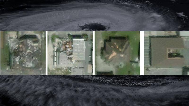
Hurricanes are one of the most destructive natural disasters, causing widespread damage to infrastructure, buildings, and human life. The aftermath of a hurricane is a critical period, where timely assessment of damage is crucial for effective disaster response and relief efforts. Traditional methods of damage assessment, such as manual surveys, are time-consuming and often hindered by inaccessible areas. To address this challenge, researchers at the Indian Institute of Technology (IIT) Bombay have developed an Artificial Intelligence (AI) model that can quickly and accurately assess building damage from aerial images.
The AI model, called SpADANet, uses spatial context to identify damaged buildings, overcoming the “domain gap” that has limited the effectiveness of previous models. The domain gap refers to the difference in appearance between images of the same location taken before and after a disaster, which can confuse traditional AI models. SpADANet’s ability to adapt to different storms with minimal data makes it a valuable tool for disaster response teams worldwide.
The Challenge of Hurricane Damage Assessment
Hurricanes can cause catastrophic damage to buildings, bridges, and other infrastructure, leaving thousands of people homeless and without access to basic necessities. The first step in responding to a hurricane is to assess the extent of the damage, which is a daunting task. Traditional methods of damage assessment involve sending teams of surveyors to affected areas, which can be time-consuming, expensive, and often hazardous.
The use of aerial images, such as those taken by drones or satellites, has become increasingly popular for damage assessment. However, analyzing these images manually is a labor-intensive process that requires significant expertise. AI models have been proposed as a solution to automate the process, but they have been limited by the domain gap. The domain gap refers to the difference in appearance between images of the same location taken before and after a disaster. For example, a building that was intact before a hurricane may be damaged or destroyed after the storm, making it difficult for an AI model to recognize.
SpADANet: A Novel AI Model
SpADANet is a novel AI model developed by IIT Bombay researchers that overcomes the domain gap by using spatial context to identify damaged buildings. The model is trained on a dataset of aerial images taken before and after a hurricane, which allows it to learn the patterns and features of damaged buildings. SpADANet uses a combination of convolutional neural networks (CNNs) and graph neural networks (GNNs) to analyze the spatial relationships between buildings and other features in the image.
The model is optimized for mobile devices, making it accessible to disaster response teams in the field. SpADANet can be used to analyze aerial images taken by drones or satellites, providing a rapid and accurate assessment of building damage. The model’s ability to adapt to different storms with minimal data makes it a valuable tool for disaster response teams worldwide.
How SpADANet Works
SpADANet works by analyzing the spatial relationships between buildings and other features in the image. The model uses a combination of CNNs and GNNs to extract features from the image, which are then used to predict the damage status of each building. The model is trained on a dataset of aerial images taken before and after a hurricane, which allows it to learn the patterns and features of damaged buildings.
The model’s architecture consists of several layers, including a CNN layer that extracts features from the image, a GNN layer that models the spatial relationships between buildings, and a fully connected layer that predicts the damage status of each building. The model is trained using a loss function that minimizes the difference between the predicted damage status and the actual damage status.
Advantages of SpADANet
SpADANet has several advantages over traditional methods of damage assessment. The model is rapid, accurate, and can be used to analyze aerial images taken by drones or satellites. The model’s ability to adapt to different storms with minimal data makes it a valuable tool for disaster response teams worldwide.
SpADANet is also optimized for mobile devices, making it accessible to disaster response teams in the field. The model can be used to provide a rapid and accurate assessment of building damage, which can inform disaster response and relief efforts. The model’s ability to use spatial context to identify damaged buildings makes it more accurate than traditional AI models.
Conclusion
IIT Bombay’s SpADANet is a novel AI model that has the potential to revolutionize hurricane damage assessment. The model’s ability to use spatial context to identify damaged buildings makes it more accurate than traditional AI models. SpADANet’s ability to adapt to different storms with minimal data makes it a valuable tool for disaster response teams worldwide.
The use of SpADANet can significantly improve real-time disaster response and relief efforts globally. The model can be used to provide a rapid and accurate assessment of building damage, which can inform disaster response and relief efforts. The model’s ability to use spatial context to identify damaged buildings makes it more accurate than traditional AI models.
As the frequency and severity of hurricanes continue to increase, the need for effective disaster response and relief efforts has never been more pressing. IIT Bombay’s SpADANet is a valuable tool that can help disaster response teams respond more quickly and effectively to hurricanes.
News Source: https://researchmatters.in/news/novel-spatially-aware-ai-model-makes-hurricane-damage-assessment-more-accurate