IIT Bombay’s AI speeds up hurricane damage assessment
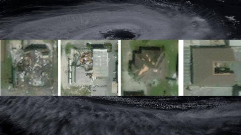
Hurricanes are one of the most destructive natural disasters, causing widespread damage to infrastructure, buildings, and human lives. The aftermath of a hurricane is a critical period where quick assessment of damage is crucial for effective disaster response and relief efforts. However, traditional methods of damage assessment can be time-consuming, labor-intensive, and often inaccurate. To address this challenge, researchers at the Indian Institute of Technology (IIT) Bombay have developed an innovative Artificial Intelligence (AI) model called SpADANet, which can quickly and accurately identify building damage from aerial images.
The SpADANet model is a significant breakthrough in the field of disaster response and relief efforts. It uses spatial context to analyze aerial images and identify damaged buildings, overcoming the “domain gap” that has limited the effectiveness of existing AI models. The domain gap refers to the difference in characteristics between the training data and the actual data used for prediction. In the context of hurricane damage assessment, the domain gap can arise due to variations in image quality, lighting conditions, and other factors. SpADANet’s ability to adapt to different storms with minimal data makes it a highly effective tool for real-time disaster response.
One of the key features of SpADANet is its ability to use spatial context to analyze aerial images. Unlike existing methods that rely on individual image features, SpADANet takes into account the relationships between different objects and features in the image. This allows it to better understand the context of the damage and make more accurate predictions. For example, if an image shows a building with a damaged roof, SpADANet can analyze the surrounding features, such as the presence of debris or fallen trees, to determine the extent of the damage.
SpADANet has been optimized for mobile devices, making it a highly practical tool for disaster response teams. In the aftermath of a hurricane, mobile devices are often the only means of communication and data collection. SpADANet’s ability to run on mobile devices allows disaster response teams to quickly assess damage and provide critical information to relief efforts. The model can be used to identify damaged buildings, roads, and other infrastructure, enabling relief teams to prioritize their efforts and allocate resources more effectively.
The development of SpADANet has significant implications for global disaster response and relief efforts. Hurricane damage assessment is a critical component of disaster response, and accurate assessments can mean the difference between life and death. SpADANet’s ability to quickly and accurately identify damaged buildings can help relief teams to respond more effectively, reducing the risk of further injuries and fatalities. Additionally, SpADANet can help to reduce the economic impact of hurricanes by enabling insurance companies and governments to quickly assess damage and provide compensation to affected individuals and businesses.
The researchers at IIT Bombay have demonstrated the effectiveness of SpADANet using a range of case studies and experiments. The model has been tested on aerial images from several hurricanes, including Hurricane Harvey and Hurricane Irma, and has shown significant improvements in accuracy and speed compared to existing methods. The results of these experiments have been published in a research paper, which provides a detailed overview of the SpADANet model and its applications.
In conclusion, the development of SpADANet by IIT Bombay researchers is a significant breakthrough in the field of disaster response and relief efforts. The model’s ability to quickly and accurately identify building damage from aerial images makes it a highly effective tool for real-time disaster response. Its ability to adapt to different storms with minimal data and use spatial context to analyze aerial images makes it a highly practical tool for disaster response teams. As the world becomes increasingly vulnerable to natural disasters, the development of innovative technologies like SpADANet is critical for reducing the impact of these events and saving lives.
The SpADANet model has the potential to be used in a range of applications, from hurricane damage assessment to monitoring the impact of climate change. Its ability to analyze aerial images and identify damaged buildings makes it a valuable tool for urban planning and development, enabling cities to better prepare for and respond to natural disasters. As the model continues to evolve and improve, it is likely to play an increasingly important role in global disaster response and relief efforts.
In the future, the researchers at IIT Bombay plan to further develop and refine the SpADANet model, exploring new applications and improving its accuracy and speed. They also plan to collaborate with disaster response teams and relief organizations to deploy the model in real-world scenarios, providing critical support to affected communities. As the world continues to grapple with the challenges of natural disasters, the development of innovative technologies like SpADANet is a beacon of hope for a safer and more resilient future.
News Source: https://researchmatters.in/news/novel-spatially-aware-ai-model-makes-hurricane-damage-assessment-more-accurate