First Detailed Look at Tsunami Captured from Space by NASA
The field of space exploration and Earth observation has taken a significant leap forward, thanks to the collaborative efforts of NASA and the French space agency, CNES (Centre National d’Etudes Spatiales). Their SWOT (Surface Water and Ocean Topography) satellite has achieved a groundbreaking feat by capturing the first detailed look at a tsunami from space. This remarkable achievement has not only expanded our understanding of these powerful natural disasters but also challenges existing beliefs about their behavior.
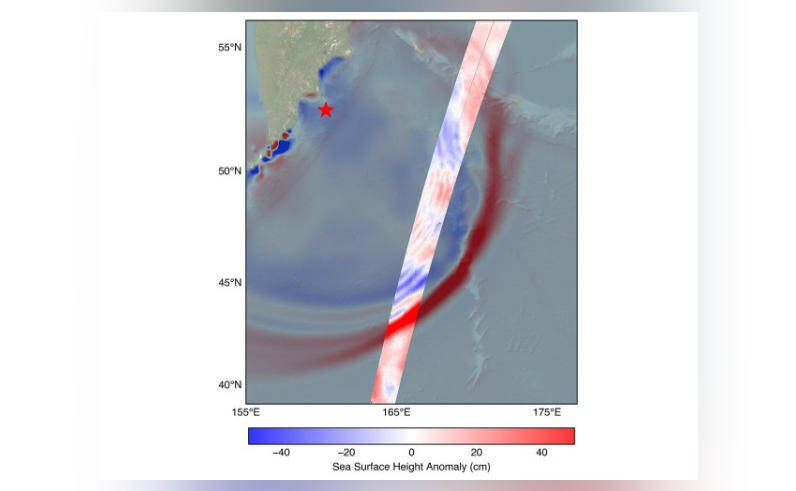
On July 30, a massive 8.8 magnitude earthquake struck off the coast of Russia’s Kamchatka peninsula, generating a tsunami that traveled across the Pacific Ocean. The SWOT satellite, launched in December 2022, was in the perfect position to track the waves generated by this powerful earthquake. The satellite’s advanced instruments and high-resolution imaging capabilities allowed scientists to study the tsunami in unprecedented detail, providing valuable insights into its behavior and characteristics.
One of the most significant discoveries made by the scientists analyzing the SWOT satellite data is that the tsunami did not maintain a single, uniform form as it traveled across the ocean. Instead, it split into multiple waves, with a large leading wave followed by smaller ones. This challenges the earlier belief that tsunamis maintain a consistent shape and size, and highlights the complexity and unpredictability of these natural disasters.
The SWOT satellite’s ability to capture high-resolution images of the tsunami from space has also provided scientists with a unique opportunity to study the wave dynamics and behavior of these events. By analyzing the satellite data, researchers can gain a better understanding of how tsunamis interact with the ocean and the surrounding coastline, which can help improve early warning systems and mitigate the impact of these disasters.
The implications of this discovery are far-reaching and have significant potential to improve our understanding of tsunamis and their behavior. By studying the dynamics of tsunamis in greater detail, scientists can develop more accurate models and predictions, which can help save lives and reduce the economic impact of these disasters. The data collected by the SWOT satellite will also be used to refine existing tsunami warning systems, allowing for more timely and effective evacuations and emergency responses.
The SWOT satellite is a state-of-the-art spacecraft designed to study the Earth’s oceans and surface water. Equipped with advanced instruments, including a ka-band radar interferometer and a lidar (light detection and ranging) system, the satellite is capable of collecting high-resolution data on ocean topography, sea level, and surface water levels. The satellite’s data will be used to improve our understanding of the Earth’s oceans, including ocean currents, ocean acidification, and the impacts of climate change.
The collaboration between NASA and CNES on the SWOT satellite mission is a testament to the power of international cooperation in space exploration and Earth observation. By working together, scientists and engineers from both agencies have been able to develop a cutting-edge spacecraft that is providing unprecedented insights into our planet’s oceans and natural disasters.
In conclusion, the first detailed look at a tsunami captured from space by NASA’s SWOT satellite is a groundbreaking achievement that has significant implications for our understanding of these powerful natural disasters. The discovery that tsunamis can split into multiple waves challenges existing beliefs and highlights the complexity and unpredictability of these events. As scientists continue to analyze the data collected by the SWOT satellite, we can expect to gain a deeper understanding of tsunamis and their behavior, which will ultimately help us to better prepare for and respond to these disasters.