First Detailed Look at Tsunami Captured from Space by NASA
The National Aeronautics and Space Administration (NASA) and the French space agency Centre National d’Etudes Spatiales (CNES) have achieved a groundbreaking milestone in the field of oceanography and natural disaster monitoring. For the first time, their SWOT (Surface Water and Ocean Topography) satellite has captured a detailed look at a tsunami from space. This remarkable achievement has provided scientists with unprecedented insights into the behavior of tsunamis, challenging earlier assumptions and paving the way for more accurate predictions and warnings.
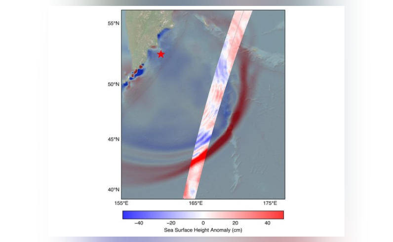
On July 30, a powerful 8.8 magnitude earthquake struck off the coast of Russia’s Kamchatka peninsula, generating a tsunami that traveled across the Pacific Ocean. The SWOT satellite, launched in December 2022, was in the perfect position to track the waves generated by the earthquake. Equipped with advanced instruments, including a radar interferometer and a lidar (light detection and ranging) system, the satellite was able to capture high-resolution images of the tsunami waves.
The data collected by SWOT revealed a complex and dynamic pattern of waves, which challenged the earlier belief that tsunamis maintain a single, uniform form. Instead, scientists discovered that the tsunami split into multiple waves, with a large leading wave followed by smaller ones. This phenomenon, known as “wave dispersion,” had been predicted by theory but never directly observed before.
The implications of this discovery are significant. Tsunamis are rare but devastating natural disasters that can cause widespread destruction and loss of life. By understanding the behavior of tsunamis in greater detail, scientists can improve their predictive models and provide more accurate warnings to coastal communities. This, in turn, can help save lives and reduce the economic impact of these disasters.
The SWOT satellite’s ability to capture detailed images of the tsunami waves is a major breakthrough in tsunami research. Previous studies have relied on limited data from coastal sensors and buoys, which can only provide a partial picture of the tsunami’s behavior. The SWOT satellite’s global coverage and high-resolution imaging capabilities have opened up new possibilities for tsunami research, allowing scientists to study these events in greater detail than ever before.
The discovery of wave dispersion in tsunamis also has important implications for our understanding of ocean dynamics. Tsunamis are not just simple waves; they are complex phenomena that involve the interaction of multiple factors, including ocean currents, wind, and the seafloor topography. By studying the behavior of tsunamis, scientists can gain insights into the underlying dynamics of the ocean and improve their understanding of other oceanic phenomena, such as ocean currents and coastal erosion.
The SWOT satellite is a joint mission between NASA and CNES, with the goal of studying the world’s oceans and surface water bodies in unprecedented detail. The satellite is equipped with a range of advanced instruments, including a radar interferometer, a lidar system, and a radiometer. These instruments allow the satellite to collect high-resolution data on ocean topography, currents, and other oceanic phenomena.
The SWOT satellite’s capabilities have far-reaching implications for a range of applications, from oceanography and climate science to natural disaster monitoring and management. By providing detailed images of the ocean surface, the satellite can help scientists study ocean currents, eddies, and other phenomena that play a critical role in the Earth’s climate system. The satellite can also be used to monitor coastal erosion, track ocean pollution, and study the impacts of climate change on the world’s oceans.
In conclusion, the SWOT satellite’s capture of a detailed look at a tsunami from space is a major breakthrough in tsunami research and oceanography. The discovery of wave dispersion in tsunamis challenges earlier assumptions and provides new insights into the behavior of these complex phenomena. As scientists continue to study the data collected by the SWOT satellite, they will gain a deeper understanding of the ocean’s dynamics and the factors that contribute to tsunamis. This knowledge will ultimately help us better predict and prepare for these devastating natural disasters, saving lives and reducing the economic impact of tsunamis.