First Detailed Look at Tsunami Captured from Space by NASA
In a groundbreaking achievement, NASA and the French space agency CNES’s SWOT (Surface Water and Ocean Topography) satellite have successfully captured the first detailed look at a tsunami from space. This remarkable feat was made possible by the satellite’s advanced technology, which tracked the waves generated by the 8.8 magnitude earthquake off Russia’s Kamchatka peninsula on July 30. The discovery has significant implications for our understanding of tsunamis and could potentially save thousands of lives in the future.
The SWOT satellite, launched in December 2022, is designed to study the world’s oceans and surface water. Equipped with advanced radar and lidar instruments, the satellite can measure the height of the ocean surface with unprecedented precision. This capability allows scientists to track ocean currents, tides, and other phenomena, including tsunamis, in real-time.
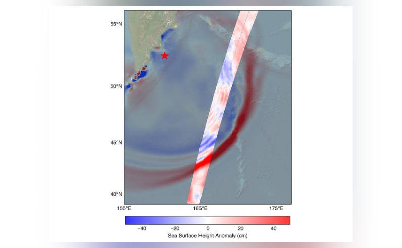
On July 30, a powerful 8.8 magnitude earthquake struck off the coast of Russia’s Kamchatka peninsula, triggering a tsunami that traveled across the Pacific Ocean. The SWOT satellite, orbiting the Earth at an altitude of approximately 820 kilometers, detected the tsunami waves and began tracking their movement. The satellite’s instruments captured detailed images of the tsunami, revealing a complex pattern of waves that challenged earlier assumptions about these powerful oceanic events.
Challenging the Conventional Wisdom
For decades, scientists believed that tsunamis maintained a single, uniform form, with a large wave traveling at a consistent speed. However, the SWOT satellite’s observations revealed a more complex picture. The tsunami split into multiple waves, with a large leading wave followed by smaller ones. This discovery has significant implications for tsunami prediction and warning systems, as it suggests that the traditional models used to forecast tsunami behavior may be oversimplified.
The SWOT satellite’s data showed that the leading wave was approximately 1-2 meters high, while the smaller waves that followed were around 0.5-1 meter high. The satellite’s instruments also captured the tsunami’s speed, which was estimated to be around 500-600 kilometers per hour. These findings demonstrate the importance of using advanced technology to study tsunamis and improve our understanding of these complex events.
Implications for Tsunami Prediction and Warning Systems
The SWOT satellite’s observations have significant implications for tsunami prediction and warning systems. By providing detailed information about the shape and behavior of tsunami waves, the satellite’s data can be used to improve the accuracy of tsunami forecasts. This, in turn, can help emergency responders and coastal communities prepare for and respond to tsunami events more effectively.
The discovery of multiple waves also highlights the importance of developing more sophisticated tsunami models that can account for the complex behavior of these events. By incorporating the SWOT satellite’s data into tsunami prediction models, scientists can develop more accurate forecasts that take into account the potential for multiple waves and other complexities.
The Future of Tsunami Research
The SWOT satellite’s achievement marks a significant milestone in the study of tsunamis. The satellite’s advanced technology and capabilities will enable scientists to study these events in unprecedented detail, providing new insights into their behavior and characteristics. As the satellite continues to orbit the Earth, it will capture data on future tsunamis, helping to refine our understanding of these complex events.
The collaboration between NASA and CNES on the SWOT satellite demonstrates the importance of international cooperation in advancing our understanding of the Earth’s oceans and natural phenomena. The satellite’s data will be made available to scientists and researchers around the world, facilitating a global effort to improve tsunami prediction and warning systems.
Conclusion
The SWOT satellite’s capture of the first detailed look at a tsunami from space is a groundbreaking achievement that has significant implications for our understanding of these complex events. By challenging conventional wisdom and providing new insights into tsunami behavior, the satellite’s data will help scientists develop more accurate prediction models and improve tsunami warning systems. As the satellite continues to orbit the Earth, it will play a critical role in advancing our understanding of the world’s oceans and helping to save lives in the face of natural disasters.