First detailed look at tsunami captured from space by NASA
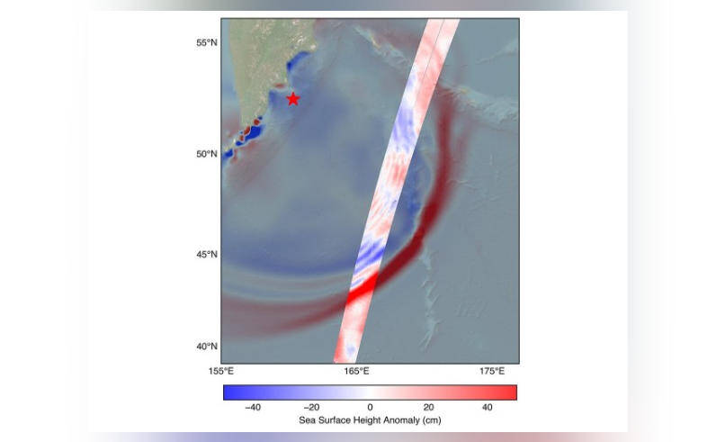
In a groundbreaking achievement, NASA and the French space agency CNES’s SWOT (Surface Water and Ocean Topography) satellite have successfully captured the first detailed look of a tsunami from space. This remarkable feat was accomplished when the system tracked the waves generated by an 8.8 magnitude earthquake that struck off Russia’s Kamchatka peninsula on July 30. The data collected by the SWOT satellite has provided scientists with unprecedented insights into the behavior of tsunamis, challenging earlier beliefs and shedding new light on these powerful natural disasters.
The SWOT satellite, launched in December 2022, is designed to study the world’s oceans and surface water. Equipped with advanced radar technology, the satellite is capable of measuring the height of the ocean’s surface with incredible precision, making it an ideal tool for tracking tsunamis. When the 8.8 magnitude earthquake struck off the coast of Russia, the SWOT satellite was in the perfect position to capture the resulting tsunami.
As the tsunami waves propagated across the ocean, the SWOT satellite tracked their movement, providing scientists with a detailed picture of the event. The data collected by the satellite revealed that the tsunami did not maintain a single, uniform form, as previously believed. Instead, it split into multiple waves, with a large leading wave followed by smaller ones. This discovery has significant implications for our understanding of tsunamis and how they behave.
The traditional view of tsunamis is that they are massive, uniform waves that maintain their shape and size as they travel across the ocean. However, the data collected by the SWOT satellite suggests that this is not always the case. The fact that the tsunami split into multiple waves, with a large leading wave followed by smaller ones, indicates that the behavior of tsunamis is more complex than previously thought.
This new information has important implications for tsunami forecasting and warning systems. By understanding how tsunamis behave and interact with the ocean, scientists can improve their ability to predict when and where these events will occur. This, in turn, can help save lives and reduce the impact of tsunamis on coastal communities.
The SWOT satellite’s ability to track tsunamis from space is a game-changer for scientists and emergency responders. Traditional methods of tracking tsunamis rely on a network of buoys and coastal sensors, which can be limited in their coverage and accuracy. The SWOT satellite, on the other hand, provides a global perspective, allowing scientists to track tsunamis in real-time, regardless of their location.
The data collected by the SWOT satellite will also be used to improve our understanding of the ocean’s role in the Earth’s climate system. By studying the ocean’s surface topography, scientists can gain insights into ocean currents, tides, and other phenomena that play a critical role in shaping our planet’s climate.
In conclusion, the SWOT satellite’s capture of the first detailed look of a tsunami from space is a significant achievement that has far-reaching implications for our understanding of these powerful natural disasters. The data collected by the satellite has challenged earlier beliefs and provided new insights into the behavior of tsunamis, which will be used to improve tsunami forecasting and warning systems. As scientists continue to study the data collected by the SWOT satellite, we can expect to learn even more about the complex and fascinating world of tsunamis.
The successful tracking of the tsunami by the SWOT satellite is a testament to the power of space-based technology and international collaboration. The partnership between NASA and CNES has resulted in a groundbreaking achievement that will have a lasting impact on our understanding of the ocean and its role in the Earth’s climate system.
As we continue to explore and study the ocean, we are reminded of the importance of international cooperation and the need for continued investment in space-based technology. The SWOT satellite is a shining example of what can be achieved when nations work together to advance our understanding of the world and the universe.
In the future, we can expect to see even more exciting developments in the field of space-based oceanography. With the continued advancement of technology and the launch of new satellites, we will be able to study the ocean in greater detail than ever before. This will lead to new discoveries and a deeper understanding of the complex interactions between the ocean, atmosphere, and land.
For now, the SWOT satellite’s capture of the first detailed look of a tsunami from space is a significant milestone that marks an important step forward in our understanding of these powerful natural disasters. As we continue to study the data collected by the satellite, we will gain a deeper appreciation for the complexity and beauty of the ocean and its role in shaping our planet.