First Detailed Look at Tsunami Captured from Space by NASA
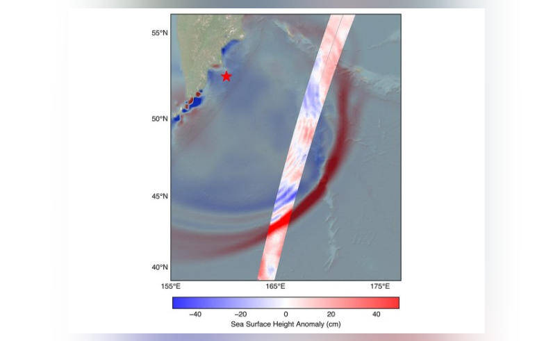
The field of space exploration and Earth observation has taken a significant leap forward with the recent achievement of NASA and the French space agency, CNES (Centre National d’Etudes Spatiales). For the first time, their SWOT (Surface Water and Ocean Topography) satellite has captured a detailed look at a tsunami from space. This groundbreaking observation was made possible by tracking the waves generated by the 8.8 magnitude earthquake that occurred off Russia’s Kamchatka peninsula on July 30.
The SWOT satellite, launched in December 2022, is designed to study the Earth’s oceans, lakes, and rivers, providing unprecedented insights into the planet’s water cycle and the impacts of climate change. The satellite’s advanced radar technology allows it to capture high-resolution images of the ocean’s surface, enabling scientists to monitor ocean currents, waves, and other phenomena with unprecedented precision.
The recent observation of the tsunami is a significant milestone in the field of Earth observation, as it provides a unique opportunity to study these powerful and destructive events in greater detail. Scientists have long believed that tsunamis maintain a single, uniform form as they travel across the ocean. However, the data collected by the SWOT satellite has challenged this assumption, revealing that the tsunami split into multiple waves, with a large leading wave followed by smaller ones.
This new information has significant implications for our understanding of tsunami behavior and the potential impacts on coastal communities. By studying the dynamics of tsunami waves, scientists can improve their ability to predict the severity and extent of these events, ultimately saving lives and reducing the damage caused by these natural disasters.
The observation of the tsunami was made possible by the SWOT satellite’s ability to capture high-resolution images of the ocean’s surface. The satellite’s radar instrument is capable of detecting even small changes in the ocean’s surface height, allowing scientists to track the movement of waves and other features with great precision. In the case of the recent tsunami, the satellite captured images of the waves as they traveled across the ocean, providing a detailed picture of their behavior and evolution.
The discovery that tsunamis can split into multiple waves has significant implications for tsunami modeling and prediction. Current models assume that tsunamis maintain a single, uniform form, which can lead to inaccurate predictions of the wave’s behavior and impact. By incorporating the new information collected by the SWOT satellite, scientists can develop more accurate models that take into account the complex dynamics of tsunami waves.
The observation of the tsunami from space also highlights the importance of international collaboration in the field of Earth observation. The SWOT satellite is a joint mission between NASA and CNES, demonstrating the value of cooperation and shared resources in advancing our understanding of the Earth and its complex systems. By working together, scientists and engineers from around the world can develop new technologies and missions that provide unprecedented insights into the planet’s behavior and evolution.
In conclusion, the first detailed look at a tsunami captured from space by NASA and CNES’s SWOT satellite is a significant achievement that challenges our current understanding of these powerful events. The discovery that tsunamis can split into multiple waves has important implications for tsunami modeling and prediction, and highlights the importance of continued research and development in the field of Earth observation. As scientists continue to study the data collected by the SWOT satellite, we can expect to gain a deeper understanding of the complex dynamics of tsunami waves and their impact on coastal communities.