ISRO Shares Before-After Satellite Pics Showing Devastation Due to Uttarakhand Flash Flood
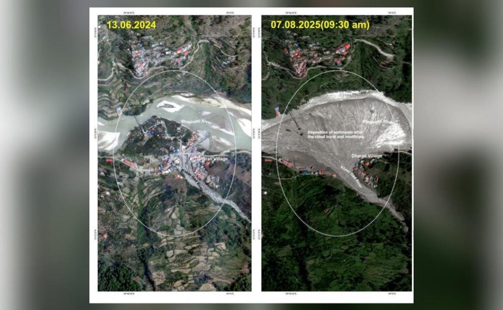
On July 11, a devastating flash flood struck the Dharali and Harsil villages in Uttarakhand’s Uttarkashi district, leaving a trail of destruction and chaos in its wake. The disaster has claimed the lives of at least five people, with many more still unaccounted for. In a bid to aid the ongoing search and rescue operations, the Indian Space Research Organisation (ISRO) has released before-and-after satellite images showcasing the extent of the devastation caused by the flood.
The satellite pictures, taken by ISRO’s Cartosat-2 series, provide a stark reminder of the magnitude of the disaster. The images, which were released on July 12, show the stark contrast between the unaffected areas before the flood and the ravaged landscape afterwards. The satellite imagery is expected to play a crucial role in helping rescue teams locate stranded individuals and reconnect the isolated region.
Before the Flood
The before images, taken on July 9, show the picturesque villages of Dharali and Harsil, nestled in the Himalayas. The villages were bustling with life, with people going about their daily activities. The images also capture the lush green forests, glistening waterfalls, and the sparkling rivers, which were once a source of joy and tranquility for the residents.
After the Flood
Fast forward to July 11, and the aftermath of the devastating flood is a stark reminder of the destructive power of nature. The images show a transformed landscape, with mud and debris-filled rivers, destroyed buildings, and uprooted trees. The once-thriving villages are now reduced to rubble, with the sounds of rescue efforts and helicopters filling the air.
The satellite pictures reveal the extent of the damage caused by the flood, which swept away homes, bridges, and roads, leaving a trail of destruction in its wake. The images also show the devastating impact on the environment, with tons of debris and mud clogging the rivers and streams, and the once-pristine forests now ravaged by the floodwaters.
Cause of the Flood Remains Unknown
Despite the devastating aftermath, the cause of the flash flood is still unknown. According to officials, the flood was triggered by a combination of factors, including heavy rainfall, landslides, and the release of water from a nearby dam. However, further investigation is needed to determine the exact cause of the disaster.
Rescue Efforts Underway
As the search and rescue operations continue, the satellite images are expected to play a crucial role in locating stranded individuals and reconnecting the isolated region. The images will help rescue teams identify areas of destruction, spot potential hazards, and plan their operations more effectively.
The satellite imagery is also expected to aid in the reconstruction and rebuilding process, allowing authorities to assess the extent of the damage and plan for rehabilitation efforts.
Conclusion
The ISRO’s before-and-after satellite images are a poignant reminder of the devastating impact of the flash flood in Uttarakhand’s Uttarkashi district. The images, which have been released to aid the ongoing search and rescue operations, provide a stark reminder of the destructive power of nature.
As the region begins the long and challenging process of rebuilding and recovery, the satellite images will serve as a powerful reminder of the devastating consequences of the flood. Our thoughts and prayers are with the affected families and communities as they work to rebuild and recover from this devastating disaster.